 "SBA Thanks You For All The Fish" (santabarbarianlsx)
05/02/2020 at 16:27 • Filed to: None
 2
2
 2
2|
"SBA Thanks You For All The Fish" (santabarbarianlsx)
05/02/2020 at 16:27 • Filed to: None | 2
| 2 |
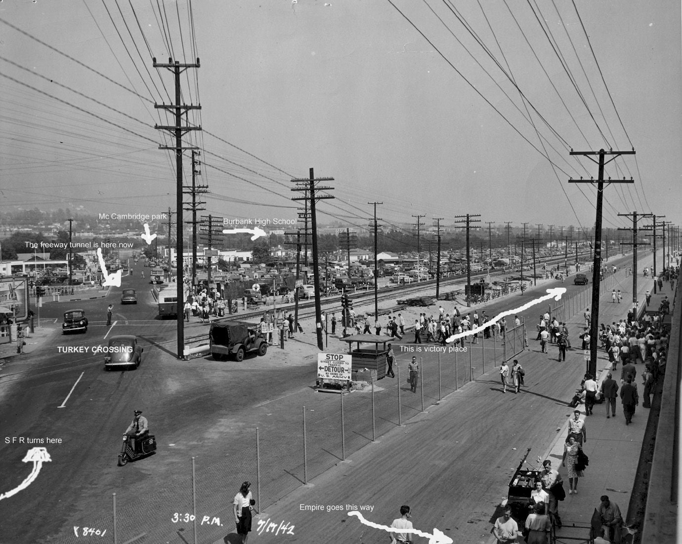
Just ran across this photo in my archives. it’s a picture taken during shift change at the original Lockheed Aircraft facility in Burbank. The location is near, but not on, the current Burbank (BUR) Airport property. The aircraft production line was in a set of buildings (they famously had camo “fake farms” on the roof during most of WWII to conceal the nature of the factory) at the intersection of Empire, San Fernando Road and the main Southern Pacific (now UP) line that ran from DTLA up to the Newhall Pass. The Metrolink AV line still runs up this alignment .
I find the photo interesting because (this was decades before I-5 got built) most of the road landmarks like SF Road and Empire are still there meeting at the RR crossing... yet the nature of the site itself is completely different. Even the park and Burbank High School are still there in those locations. However, Lockheed is long gone and the factory site re-developed into “retail”. From where the camera sits, there is now an Outback Steakhouse and Olive Garden, with a nice REI Store sitting just behind where the photographer would have been. Strange to think that P-38s flowed out of the factory then, but largely the aircraft manufacturing has long since flown the coop from LA to Palmdale and Texas.
So, it’s weird to see this spot of LA just as the war was ramping up, LA was booming with men and women riveting Army Air Corp planes together by the thousands. A moment captured in time.
BTW, this was known to the locals as “Turkey Crossing” for decades, due to a road accident at the tracks many years ago-- involving farmers hauling turkeys to market. LA was a different place back then.
 John Norris (AngryDrifter)
> SBA Thanks You For All The Fish
John Norris (AngryDrifter)
> SBA Thanks You For All The Fish
05/02/2020 at 17:50 |
|
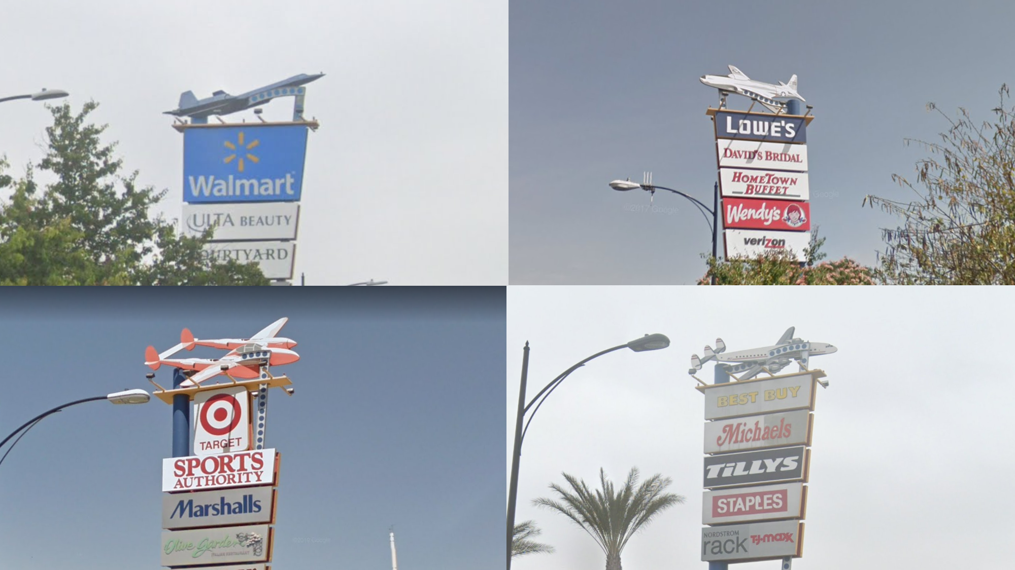
So I worked in Burbank from 1985 - 1991. That was the B-1 plant at Victory Place and Empire where they made P-38's in WWII . As you pointed out it it was away from the airport where they built other aircraft . So during the war they used to fly the P-38's off the street that paralleled the other railroad tracks s outh of the plant.
So I had to go check google street view to see what Victory Place looks like now. They were tearing down the B-1 plant at the time . I love what they did . An SR-71 Walmart, a P-80 Lowes, a P-38 Target, and a Connie Best Buy. You just can’t beat that.
|
SBA Thanks You For All The Fish
> John Norris (AngryDrifter)
05/02/2020 at 18:06 |
|
interesting. I’d no idea the plant was there that late. You always see those “airplane themed” commercial signs from the 5 in that section, so that’s the place.
Also didn’t realize they flew off the street— I’d assumed they closed Empire and taxi’d over there, although there are SO many “formerly w as an airfield” locations around LA. (The Disney-ABC lot between Burbank and Glendale still has the part of the runway used as a street, from when the Glendale Grand Central Terminal Airport was ‘the big deal’ airport for LA) that it wouldn’t have surprised me to find there was a strip over between Victory and Empire somewhere.
I think the Space Shuttle factory (Downey) was one of the last to close up shop. That’s also been converted to retail, oddly. For a city perpetually short of residential space, this place sure converts a lot of brown field into “retail”...
Thanks again for the background!